![]()
|
|
|
||||
|
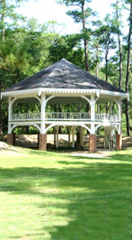
This pavilion was designed by Thomas K. Sully for the Mississippi exhibit of the World's Industrial and Cotton Centennial Exposition of 1884, which was held in New Orleans. After the exposition closed the pavilion was taken apart and reassembled on this site in 1887 above the then famous free flowing spring. Walk under the pavilion. The raised concrete area is where the water used to flow into a 12 foot deep cement lined pool that was covered in glass to keep dirty things out of it. People who were alive in those years wrote that you could see a pebble in the bottom of the well. Notice the levee built around three sides of the pavilion. The levee was reinforced and the brick portion of the columns was raised about 20 years ago. The park fills with water, covering the parking lot easily, during floods that happened regularly until this dry spell of the last several years. Discuss the powerful forces of erosion or how much water flows in the Abita River during a heavy rain. Discuss the effect that development can have on flood waters downstream. (Water is not absorbed by roofs or parking lots, and each mature tree can suck up many, many gallons of water during a rain.) Notice the foot bridge across the Abita River. An older foot bridge used to exist in about the same place. It connected directly to the second floor of the pavilion and led to large hotels that were located across the river. Abita Springs was a hugely popular summertime destination for people escaping from the heat and yellow fever epidemics in the city. They flocked toward the fresh spring water and "Ozone Belt" air. Tourists crossed Lake Ponchartrain by steamboat and then a surrey or "tallyho" from Mandeville to Abita Springs. The entire trip from New Orleans to Abita Springs took about 5 ½ hours. Soon a streetcar or trolley was built from Abita to the lakefront and the first real train arrived in 1887. The depot was across from what is now Rauch's Grocery in the middle of town, just one block outside of the entrance to this park. The track circled around the eastern side of the Lake, reducing the trip to 2 or 3 hours and bringing visitors in even greater numbers. This little town had over 300 hotel rooms in the early 1900's! Several of the big hotel buildings were surrounded by smaller cottages for rent to families for a week or a month. Discuss where the hotels went… (Eventually, automobiles let people drive in whatever direction they wanted to go on vacation, mosquito spraying reduced outbreaks of yellow fever, and the smaller cottages became permanent homes. Most of the large old hotels were empty or had burned by the 1960's. They were made of pine and burned easily one at a time. The Long Branch Hotel, located across the river and through the woods from here, was one of the first hotels built in 1880, and one of the last to burn in the 1980's. Try to imagine what it was like in the early 1900's with over 300 hotel rooms and trains that could bring in over 400 people at a time… This park probably looked the same, with one important exception. Old pictures of this very "progressive" time show most places with almost no trees. Extensive aggressive logging went on in St. Tammany Parish from the 1850's into the 1900's. What you see is not old growth forests. At one time, old forests of tall yellow pine trees extended from northern Florida into Louisiana. The first Europeans told stories of being able to ride horses through these forests without any undergrowth slowing them down. Discuss why, was someone using a riding lawnmower in the 1700's? (Because the trees grew so tall and dense they blocked the sunlight to the undergrowth.)
Notice how high the road bed of the Trace is built. (During the May Flood of 1995, the Trace was the only way in and out of Abita.) Discuss with your students why it is built like this. (Because it was a train track just 10 years ago, and train tracks have very slight grades.) Walk two blocks to a bridge across a small creek. Discuss how this raised roadway effects local drainage. Discuss the conversion of the Railroad to Bike Trail. Discuss the socioeconomic… Why are train tracks not being used as much as they were? Discuss the environmental… How might the conversion to a bike trail effect the plants and creatures living right around the tracks? Have students take turns estimating a decameter (ten meters), and confirm the distance by measuring with a meter long stick, or a rope previously measured and cut to ten meters, ten yards. Take along a yardstick and estimate, measure, and compare to ten yards. UCM Museum 22275 Hwy. 36 Abita Springs LA 70420 Tel. 985-892-2624 E-MAIL for field trip information Copyright 2001 by John Preble |